
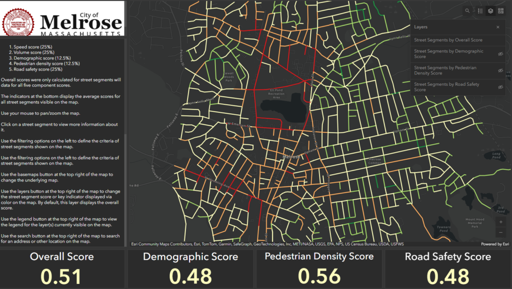
The City of Melrose Engineering Department has released a new Traffic Calming Prioritization Tool, a GIS tool which is designed to help the city use data to “prioritize traffic calming efforts.” According to the city, the tool ranks every street segment in Melrose based on:
- Demographic factors (e.g. children and seniors, median household income, etc)
- “Pedestrian density” (e.g. walking access to critical amenities such as grocery stores, schools, health care facilities, etc).
- Number and seriousness of recent crashes
- Speeding data
- Traffic volume data
More information can be found within the tool itself. In general, higher numbers indicate a greater need for traffic calming. Per this data, the streets in Melrose which are most in need of additional traffic calming measures are:
- West Wyoming, between Washington and the Stoneham border
- Main Street between Emerson and Green Street
- The streets around Ell Pond and the middle/high school complex, including Emerson, Tremont, Crystal, Melrose, and Albion.
- Franklin, between the Highlands and Vinton
Some streets which are plainly very dangerous — e.g. Lynn Fells Parkway, the Fellsway, Lebanon, Upham, etc — only fall into the “moderate” or “low” category based essentially on walkability ratings, as the tool views them as having poor road safety scores but low walkability or demographic scores, i.e. the tool does not think these roadways will have as many vulnerable users.
This toolkit was produced in conjunction with Neighborways Design, an engagement that was funded in the summer of 2022 through federal ARPA funding. While we are not certain how or when the city will use this tool, we believe it could be used to prioritize the rollout of temporary “traffic calming pilots” such as the ones which have recently been featured on Howard Street, Woodland Ave, and Lynde Street. We do not believe the city has formalized an application process or guidelines for the use of these pilots, which use materials that were purchased via MassDOT Shared Streets & Spaces Grants in 2022. We also believe the city should be using this tool in conjunction with all road work, in accordance with the city’s Complete Streets program (e.g. repavings, redesigns, grant opportunities, Chapter 90 funding, etc).
We encourage residents to use the tool as part of their own engagement with the city to prioritize city funds (and attention) on protecting our most vulnerable road users through a proactive approach to road designs which reduce vehicle speeds and separate vulnerable users from car traffic as much as possible.
Kudos to Mayor Paul Brodeur for funding this initiative and to City Councilor Ryan Williams for all his pushing behind the scenes to make this tool come to fruition.